
The Aletsch Glacier (German: Aletschgletscher) or Great Aletsch Glacier (German: Grosser Aletschgletscher) is the largest glacier in the Alps. It has a length of about 23 km (14 mi) and covers more than 120 square kilometres (46 sq mi) in the eastern Bernese Alps in the Swiss canton of Valais. The Aletsch Glacier is composed by three smaller glaciers converging at Concordia, where its thickness is estimated to be near 1 km (3,300 ft). It then continues towards the Rhone valley before giving birth to the Massa River.
The whole area, including other glaciers is part of the Jungfrau-Aletsch Protected Area, which was declared a UNESCO World Heritage site in 2001.
The first sight of this awesome phenomenon is something a world apart from those diagrams in geography lessons, because this thing is enormous, ancient and on the move. Not millions of years ago, but now. And right there, from horizon to horizon, not a distant tongue of snow and ice poking over a rock wall.
This hike makes a memorable circuit of the Eggishorn, traversing along the slope above the immense glacier, before looping back to take in Southward-looking vistas of the Monte Rosa range and the Matterhorn. It's a relatively flat walk too, with not much climbing required at all.

Tourism
The area of the Aletsch Glacier and some surrounding valleys is on the UNESCO World Heritage list, thus it is protected and the facilities are mostly restricted the external zones. The region between Belalp, Riederalp and Bettmeralp (which is called Aletsch Region) in Valais gives access to the lower part of the glacier. The Bettmerhorn and Eggishorn are popular view points and are accessible by cable car. The Massa river can be crossed since 2008 by a suspension bridge, thus allowing hikes between the left and the right part of the glacier.
The Jungfraujoch railway station (3,450 m) gives a direct access to the upper Aletsch Glacier as well as the normal route to the Jungfrau. It can be reached only from Interlaken in the canton Berne. Glacier tours can be done with the help of the Konkordia Hut or the Hollandia Hut, eventually reaching other glaciers in the massif.
On the Riederfurka, at 2,065 metres between Riederalp and the glacier, is located the historic Villa Cassel, former summer residence of many numerous famous and influential guests from the worlds of politics and finance. The house is now one of the centers of the environmental organization Pro Natura, which hosts a permanent exhibition about the site.
Getting there and back
Both the start and the end of this hike are reached by cable car, from Fiesch and Betten respectively in the valley below. Both Fiesch and Betten lie on the Furka Oberalp train line, between Brig and Andermatt.
From Zurich, it's possible to do as a day trip, but it's a looong day trip. In this case you can make a loop, going via Arth-Goldau and Göschenen to Fiesch, and then coming back from Betten via Brig, Kandersteg and Bern. A day pass for the trains is CHF 56, plus CHF8.60 and CHF4.20 for the cable cars.
For overnight trips obviously you can't use a day pass, and then it makes a difference that from Zürich the Brig way is more expensive than the Göschenen way. With halbtax a return ticket for the Göschenen way costs CHF 60 for the train, plus again the CHF 8.60 and CHF 4.20 for the cable cars.
The walk
Fiescheralp - Gletscherstube - Märjelensee - Biel - Moosfluh - Blausee - Bettmersee - BettmeralpPick up the free "Wanderwege mit Pfiff" card from the cable car station for a basic plan of the first stage of the walk, unfortunately the best free map (Aletsch Bettmeralp Sommer Pauschalen 2002) is only available at the end of the walk - try your local tourist information centre or use the one from the website, see link below.
Fiescheralp is a popular spot for paragliders and hang gliders. Make your way between them to the right, signposted Märjelen, also numbered 53. This wide, easy track descends slightly as it follows the side of the valley to the NorthEast. Ignore signs to "Tunnel mit Licht" (unless you prefer long, dark tunnels to the mountain scenery!) and continue towards Märjelen on the lower path. After about 25 minutes, just after the ugly avalanche barriers, you get the first glacier view, although this isn't the big one, this is just the Fieschergletscher giving you a taster. Continue onwards and climb slightly up to a crucifix on a vantage point, after about another 35 minutes.
The trail then turns round the shoulder of the Eggishorn, leaves the valley behind and heads past a small lake to reach the restaurant Gletscherstube after about half an hour. Although this restaurant seems hidden away in the middle of nowhere, it is very popular.
Follow the signs for Bettmeralp/Riederalp down to reach another lake, very beautiful with the first (tantalising) views of the glacier beyond. A little further on and you finally reach the full expanse of the glacier, about half an hour on from the Gletscherstube, with the Jungfrau over to the right, the broad moraine trails sweeping round in a massive arc, the Aletschhorn towering straight ahead, and more snowy peaks lining up to the left. Clamber around the roughly worn rocks for the photos that you will find it impossible not to take.
Continue alongside the glacier, traversing the steep slope between the mountain sheep and the marmots, to reach the signpost at Roti Chumma after about half an hour. Follow the signpost to Riederalp and Blausee to reach the broad ridgetop after an hour, marked on the map as Biel but not signposted as such. From here, as well as the views over the glacier side, the views also extend right out in the other direction, to the valley from which you started, and the massive peaks to the South. The footpaths are numerous and confusing here, but the chairlift station at Moosfluh is clearly visible and only a short distance away. Here there is a board showing the panorama, including the enormous Monte Rosa and the characteristic spike of the Matterhorn.
Take the path straight ahead to the right of the chairlift, signposted Hohfluh, but look out for the left-hand branch marked with red and white. This leads down to a signpost, pointing you leftwards back towards the chairlift cables to reach the Blausee. From here you can see the larger Bettmersee, straight ahead and 200m lower, towards which the unsignposted track descends in switchbacks. Continue on the right-hand side of this large and beautiful lake, to hit the Bettmersee signpost after about 25 minutes from Blausee.
Descend into the pleasant resort of Bettmeralp, turning right after the Sportcentrum and following the pedestrianised road through the village. Look out for the cable car lines, with the station about 10 minutes from the Bettmersee. This cable car runs regularly right through until 10:45pm, descending in two stages to the rail station of Betten (buses replace the trains in the evening). It's worth checking the cable car timetable beforehand, so that you don't just miss one of the hourly connections from Betten.
Variations
Check out the panoramic map, there are plenty of trails. For example, cut the hike shorter by heading straight down to Bettmeralp from Biel instead of going via the Blausee, or make it longer by continuing alongside the glacier to Aletschwald and then cutting back to Riederalp.It's also possible to extend the hike up to the top of the Eggishorn (2929m) and then drop down to the Gletscherstsube to continue the hike. From Fiescheralp it's just over an hour up to Elselicka, then about 20 minutes up the ridge to the cable car station. The rocky summit itself is another 15 minutes or so over the wild rocks. Then from the cable car station it's about 1h15 down to the Gletscherstube, ready for the loop round the back. However, the close-up views of the glacier from lower down are actually more dramatic and impressive than the birds-eye views from the Eggishorn. And the panoramas are more enjoyable without the crowds around the top cable car station. Lots of families seem to take the cable car up to Eggishorn and walk down to Fiescheralp, which is probably more difficult and less spectacular than they imagine.
The pics
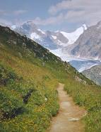
The path heading towards the Fiescher Gletscher
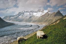
Sheep enjoying the view along the mighty Aletsch Gletscher

Tidak ada komentar:
Posting Komentar